I’ve done my best to interpret all the comments on the maps, but if you spot any errors or want to add anything, this is the thread to do it in! These have been shared with the DCC. Click on the links to jump to individual discussion pages.
General
- Better bike map online (e.g. Christchurch example: https://ccc.govt.nz/transport/getting-around/cycling/cycling-maps)
- Note that there are maps (in the form of pdfs) online. Not ideal, but better than nothing: Link to DCC page
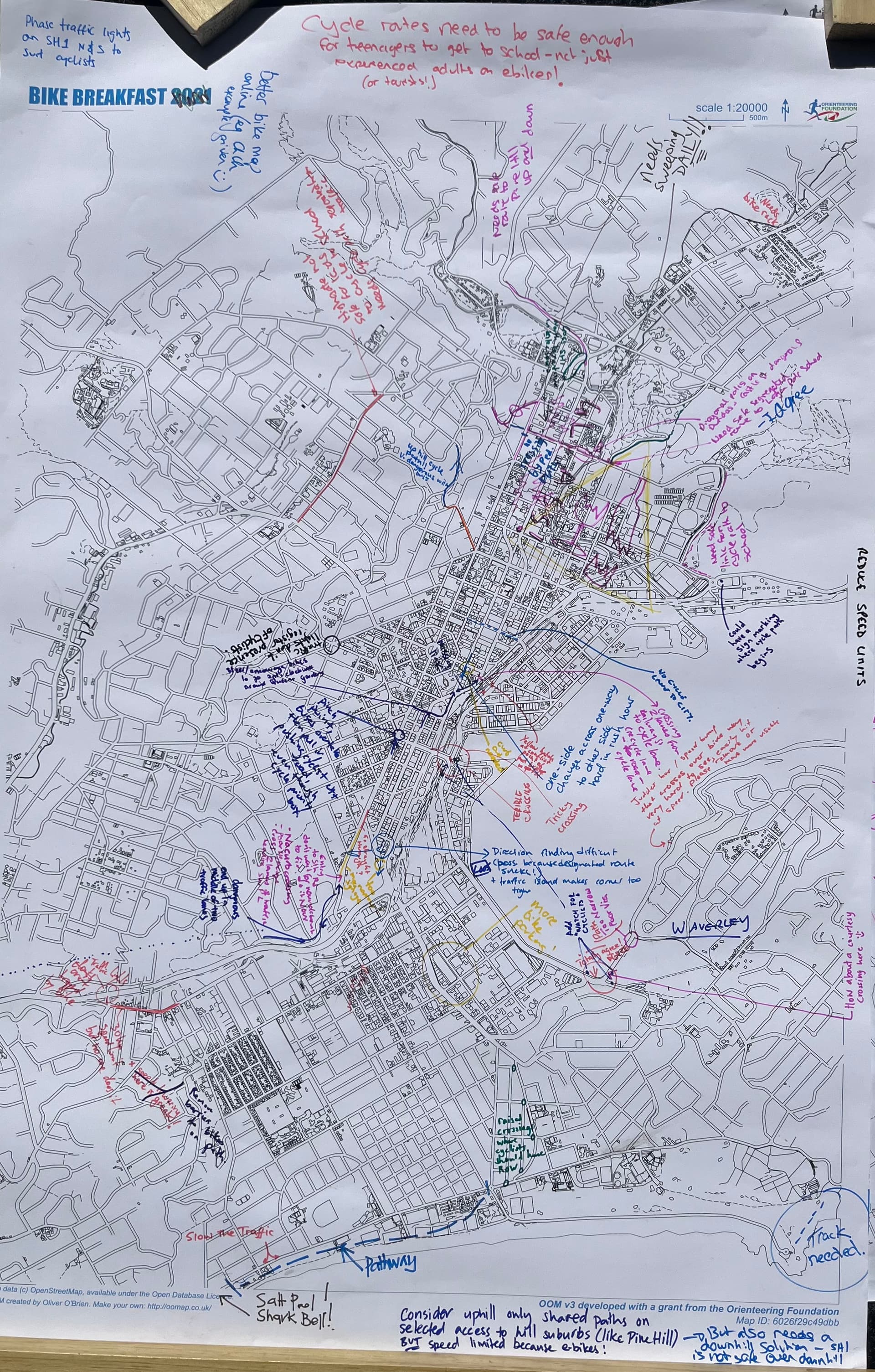
- Cycle routes need to be safe enough for teenagers to get to school - not just experienced adults on ebikes! (Or tourists)
- Reduce speed limits
Cycle routes
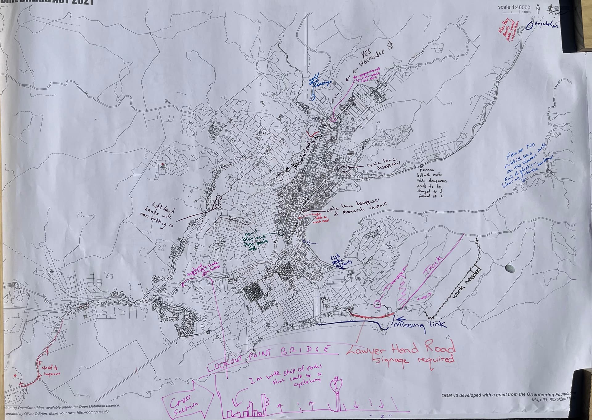
- Anzac Av near Stadium: disappears.
- Ravensbourne: “Narrow bollards make this dangerous changes to 1 instead of 2” ???
- Ravensbourne rail crossing impossible with hand-cycle
- MacBay Beach path / road interaction - Vegetation.
- The Cove: Please no rubbish nibs on the shared path (full of plastic blowing into the harbour)
- Anderson Bay Shore Street - link park to the trails [cycle path
- Fryatt St. Disappears a Monarch car park.
- Wharf st, just before Portsmouth drive: very narrow.
- Princes’s Street at Andersons bay rd junction. Pain bike lane thru going south.
- Lookout point bridge (under Riselaw Road) - there is a 2m wide strip of roicks that could be a cycleway, avoiding having to climb up ramp to Ridelaw road.
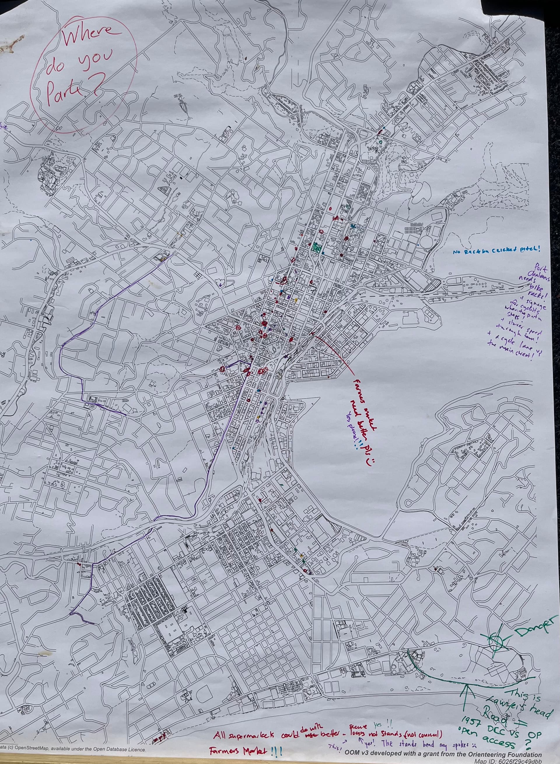
- Signage of road through the Chisholm Park golf course: (Apparently it is Lawyers Head Road. Ref 1957 DCC vs OP. Open access?) Or a path John Wilson drive to Tomahawk Road?
- Upgrading the track from Tomahawk Lagoon (Tomahawk Rd) to Highcliff road could be a good way to avoid having to cycle up the busy part of Highcliff.
- SH1 cycle paths need sweeping DAILY
- Safe route top Pine Hill … up and down.
- Highgate not safe for kids to cycle to school - needs cycle path separated from traffic
- Pitt street and drivers road - uphill cycle path needed. There is space!
- George Street North at Dundas street - no crossing where pedestrian path
- Need safe segregated route to Logan Park High School [Butts road]
- Sign at Anzac Rd/Ravensbourne roundabout marking where cycle path begins
- St Andrews street to city [link with harbour paths]
- Vauxhall boat club - judder bars/speed bumps that cross the cycle path very hard to see and easily hit at speed - please remove or make more visible.
- Southern end of Vogel Street: Direction finding difficult (possibly because designated route sucks!.
- Southern end of Vogel Street: Traffic island makes corner too tight
- Royal Cres: There are raised crossings where cyclists should have right of way!
- Victoria Road between John Wilson drive and St Clair: Slow the traffic. How about a pathway (eg Kettle park),
- Hazelhurts pass to Rainton Rd paths: remove barriers to bikes on paths.
- Steer/Encorage people to go round Queens Gardens to avoid having to cross SH1
Danger areas
- Tomahawk Rd Cemetery Junction (Tahuna Road/Minto Street/Tomahawk Road)
- Kenmure Rd. nr Newport st and Roseberry st. Cars cut in on the bends.
- Pine Hill rd just after SH1 junction. “Add drop crossings” ???
- Warrender and Lachlan Ave: Uphill shared footpath, with dropped curb and crossing on Queen St : Warrender and Lachlan Ave, with dropped curb and crossing on Queen St - [several people agreed]
- Great Kings Street North, adjacent to the botanical Gardens. Not a safe place to change sides. Make foot path shared.
- Diagonal Parking on Dundas and Castle street is dangerous
- Wharf Street crossing under flyover - several comments: “needs traffic lights”, “Tricky Crossing”, “Terrible Crossing”. “Add watch for cyclists signs”
- Portsmouth drive southern crossing - various suggestions - signage, courtesy crossing.
- Portobello rd path at Anderson Bay - too narrow, poor visability
- South Road south of SH1 is 30 kph but ignored - enforcement?
- South Road north of SH1 has very tight pinch points especially city bound where the historic island does not help (+ vegetation is still overhanging and blocking visibility)
- Princes street entry to South Road - don’t wait for a roundabout to fix: do it now (No curb crossing, poor signage, having to cross 2 lanes of traffic heading south). Dangerous - you end up in the middle of 2 traffic lanes.
- Princes street at Stafford St: Pinch point where buses overtake then pull in pushing cyclists oof the road, even though there is a cycle priority box.
Traffic lights
- Traffic lights not responding to bikes
- Stuart Street near Moana poo:l don’t respond to bikes
- Octagon: don’t respond to bikes
- Barns Drive/Caversham Valley Rd (SH1): don’t respond to bikes
- Rattray St/York Pl/Arthur St: don’t respond to bikes
- Phased traffic lights on SH1 North and South to suit cyclists
Parking
- All supermarkets could do with better stands - secure loops, not wheel stands. [3 other people agreed with this… “Yes, the stands bend my spokes”
- Farmer’s market needs better bike parking.
- Port Chalmers needs bike racks + signage for cyclists when the path stops (currently leaves tourists not knowing the way to the ferry!) + slower speed through town + a cycle lane up the main street.
- Brockville shops
- Mitre 10
- Bunnings
Maps
The genesis of this page came from the following maps collected at the Bike breakfast. Click on the thumbnails to enlarge:
Outer